LETO — Low-Earth Triage & Operations
A web-first satellite decision cockpit that fuses live disaster feeds with satellite access windows, revisit timelines, and downlink planning. Open source under Apache 2.0.
Human Engine Labs
The Challenge
Satellite emergency response is a race against the clock. Analysts must decide which incident to task first, but they lack a single view that combines live disaster data with orbital access and ground station availability.
Existing mission planning software is either classified, prohibitively expensive, or locked behind vendor ecosystems. Small teams and NGOs are shut out of capabilities that large agencies take for granted.
External data feeds are unreliable. When NASA FIRMS or GDACS goes down, most tools simply break. There is no graceful degradation, no cache strategy, and no transparency about data latency.
Our Approach
We designed LETO as a browser-first application with no installation required. The entire stack runs client-side where possible, with serverless data ingestion for live feeds.
We implemented SGP4/TLE propagation for real satellites and a circular orbit generator for synthetic constellations, giving users flexibility to plan with existing assets or design future ones.
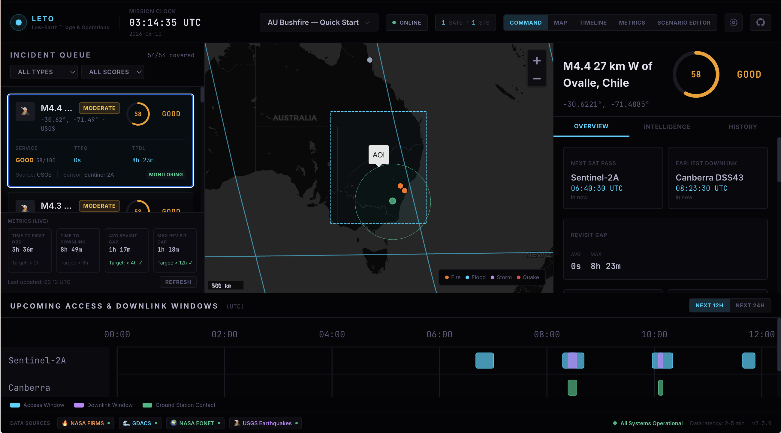
The scoring engine combines time-to-first-observation (TTFO), time-to-downlink (TTDL), and revisit gap coverage into a single 0-100 serviceability score per incident. This lets operators triage visually instead of manually comparing timelines.
We built resilience into the data layer. Every external feed has explicit latency warnings, cache indicators, and fallback states. When a feed fails, the UI remains operational and clearly communicates what data is stale.
Deliverables & Outcomes
What we delivered
- Live disaster feed ingestion (NASA FIRMS, GDACS, NASA EONET, USGS)
- SGP4/TLE orbit propagation with circular orbit generator
- Access window calculator for AOI imaging and ground station contacts
- Revisit gap analysis and time-to-information metrics (TTFO, TTDL)
- Serviceability scoring (0-100) per incident
- Interactive tactical map with satellite basemap and layer controls
- Gantt timeline for pass scheduling and downlink windows
- Real-time scenario editor for AOIs, satellites, stations, and horizons
- Automated CI/CD pipeline deploying to GitHub Pages
Measured results
4+
Data Sources
NASA FIRMS, GDACS, NASA EONET, USGS Earthquakes
2+
Continents
Australia, Africa, and global coverage
60 FPS
Frame Rate
UI performance across desktop and tablet
Project Gallery
LETO is being extended with custom constellation designer, multi-station downlink optimisation, and integration with commercial imagery APIs for automated tasking workflows.
See how the protocol works
Each case study demonstrates how Respectful Mediation, Structured Cultivation, and Natural Harmony operate at scale.